Geology of the İdiş Dağı - Avanos
ABSTRACT
 The
basement rocks of the study area constitute Mesozoic aged Asigedigi Metamorphics,
that represent the uppermost unit of the Central Anatolian Metamorphics and
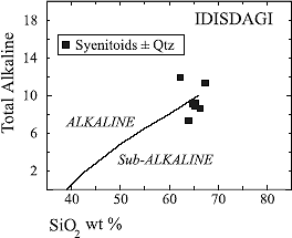
consist of platform type meta-carbonates. İdiş Dağı Syenitoid, composed of quartz
syenite, alkali feldspar quartz syenite and quartz monzonite intruded the Asigedigi
Metamorphics, and generated contact metamorphic zones. Karahıdır Volcanics
are found as dykes cutting the İdiş Dağı Syenitoids and as blocks in the Göynük
Volcaniclastic Olistostrome. Göynük Volcaniclastic Olistostrome unconformably
covers the basement rocks. It is formed within a fault-controlled extensional
basin in Uppermost Cretaceous-Lower Paleocene period, and includes the olistoliths
of the Karahıdır Volcanics and İdiş Dağı Syenitoids.
The
basement rocks of the study area constitute Mesozoic aged Asigedigi Metamorphics,
that represent the uppermost unit of the Central Anatolian Metamorphics and
consist of platform type meta-carbonates. İdiş Dağı Syenitoid, composed of quartz
syenite, alkali feldspar quartz syenite and quartz monzonite intruded the Asigedigi
Metamorphics, and generated contact metamorphic zones. Karahıdır Volcanics
are found as dykes cutting the İdiş Dağı Syenitoids and as blocks in the Göynük
Volcaniclastic Olistostrome. Göynük Volcaniclastic Olistostrome unconformably
covers the basement rocks. It is formed within a fault-controlled extensional
basin in Uppermost Cretaceous-Lower Paleocene period, and includes the olistoliths
of the Karahıdır Volcanics and İdiş Dağı Syenitoids. 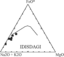 The
late Lower Paleocene-Upper Paleocene Yeşilöz Formation consists of the
Saytepe Conglomerate Member and the Asaftepe Member and represents the
terrestrial and lacustrine depositional environment. Middle Eocene Mucur Formation
characterising shallow marine (reefal) deposition transgressively overlies the
basement rocks. It is suggested that in the Early Miocene, a compressional system
effected the İdiş Dağı Area, and the basement rocks were thrusted over the Tertiary
cover units. The neotectonic period started in Late Miocene in the study area.
In this period a new tensional system became effective, Ürgüp and Asarcık
Formations are deposited within the basins which are controlled by the Central
Kızılırmak Fault Zone. The Quaternary aged travertine occurrences and talus
deposits are also related to this fault zone. The Karataş Volcanics and Kızılırmak
River terraces of Quaternary of age are mainly controlled by the Central Kızılırmak
Fault Zone.
The
late Lower Paleocene-Upper Paleocene Yeşilöz Formation consists of the
Saytepe Conglomerate Member and the Asaftepe Member and represents the
terrestrial and lacustrine depositional environment. Middle Eocene Mucur Formation
characterising shallow marine (reefal) deposition transgressively overlies the
basement rocks. It is suggested that in the Early Miocene, a compressional system
effected the İdiş Dağı Area, and the basement rocks were thrusted over the Tertiary
cover units. The neotectonic period started in Late Miocene in the study area.
In this period a new tensional system became effective, Ürgüp and Asarcık
Formations are deposited within the basins which are controlled by the Central
Kızılırmak Fault Zone. The Quaternary aged travertine occurrences and talus
deposits are also related to this fault zone. The Karataş Volcanics and Kızılırmak
River terraces of Quaternary of age are mainly controlled by the Central Kızılırmak
Fault Zone.
- AUTHORS:
- Köksal-Serhat, İller Bankası Genel Müdürlüğü, Ankara.
Göncüoğlu M. Cemal, Orta Doğu Teknik Üniversitesi, Jeoloji Mühendisliği Bölümü,
06531 Ankara.
- AUTHOR AFFILIATION:
- İller Bankası, Genel Müdürlüğü, Ankara
- SOURCE:
- Bulletin of the Mineral Research and Exploration Institute of Turkey. 119;
Pages 41-58. 1997
- REFERENCE SOURCE:
- GeoRef, Copyright 1998, American Geological Institute
- ILLUSTRATION:
- Refs: 36; illus. incl. strat. col., 1 table, sketch maps
- PUBLISHER:
- MTA: Maden Tetkik ye Arama Enstitüsü. Ankara, Turkey. 1997
- ISSN:
- 0026-4563
- COORDINATES:
- LAT:
36°00"00' - 38°00"00' N
LONG: 38°47"00' - 34°52"00' E
-
-